
Interactive Globes will allow you to create as many globes as you want to use on your WordPress website.
Create your first globe in minutes! Use it to highligh locations, offices, projects, representatives, statistics, or other interactive marker visualization you need!
Click to see them in action
-

Graticules
Graticules are the grid lines that represent the Earth’s coordinate system that can be enabled to enhance the clarity and educational value of your maps.
-

Custom Image Markers
Add custom image markers to take your map identity even further. Upload your own markers.
-

Hollow Transparent Globe
You can set the globe to be transparent and choose a region layer to display, to create a unique effect for your world map.
-

Live Filter
Display multiple sources of data in the same globe and display a live filter to show/hide the entries.
-
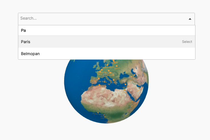
Search Dropdown List
Display the list of entries in the globe in a dropdown with search and autocomplete features.
-

Interactive Regions
Add a layer of interactive regions, that can be countries or continents and add tooltips and click actions to them.
-

Click Actions
Set the globe elements to trigger click actions, like display content outside the map or in a lightbox or open a custom URL.
-

Auto Rotate and other Animations
Set the globe to auto-rotate, animate in and a custom initial center to match your needs and impress your visitors.
-

Text Labels With Dots
You can add text labels that display together with a dot, select the dot size, add a tooltip and set a click action.
-

3D Cylinder Point Markers
You can set the height and radius of the markers, choose a color, add a tooltip and a click action.


More features soon!