


Travelling south from the Midlands along the Fosse Way, we took a detour to have a wander around the lovely Rollright Stones. It’s been a couple of decades since I was last at Rollright, thankfully this lovely place hasn’t changed much.
The Rollright Stones consist of three monuments, The Whispering Knights, The King’s Men and The King Stone. The sites are all close together, accessible and just a short walk from the road.
In his book, The Modern Antiquarian, Julian Cope describes the Rollrights as ‘From the point of view of the modern traveller, the Rollright Stones are probably one of the most important single monuments in this book. For, here on the ancient Cotswold ridgeway known as the Jurrassic Way, in the heart of the middle of England, and with no other stone circle as their neighbour, The Rollright Stones have come to play a vital lifeline role in the lives of pagans and occultists down the ages.’


The Whispering Knights have been interpreted as the remains of an Early Neolithic Dolmen and is one of the earliest megalithic funerary monuments in Britain. The dolmen probably consisted of two or three upright stones supporting a capstone.


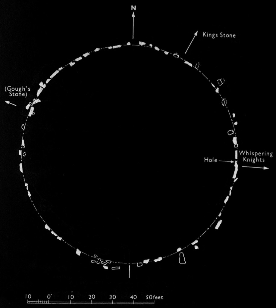


The King’s Men is a stone circle built using beautiful gnarly limestone. The stones form a perfect circle and may have had two portal stones at its entrance. The design and age of this monument places it into the same category of circles such as Castlerigg and Swinside in Cumbria and Ballynoe and Beltany in Ireland. These circles are amongst the oldest in our Islands.
‘The evocative stone circle of the Rollright Stones stands on a prehistoric trackway at the edge of a ridge falling steeply to the north…Its weathered stones of local oolitic limestone were vividly described by Stukeley as ‘corroded like worm-eaten wood, by the harsh jaws of time.’ Aubrey Burl

The King Stone is a single standing stone that was erected during the Bronze Age. Its strange shape has been sculpted by superstition, centuries of people chipping off bits of stone to carry as amulets, . Close to the King Stone are the remains of a Bronze Age round barrow. The only visible remnant of the 17m mound are a few loose stones and one large stone that is thought to be the capstone of the barrow’s chamber.
The Rollright Stones are strange and wonderful, the ruined dolmen and the age and design of stone circle are more typical of Neolithic megalithic monuments that are found along the Atlantic seaboard. The site also has evidence of later Iron Age occupation, a Roman settlement, and a nearby Saxon Burial ground.
I think the key to this site is its location on the edge of a limestone ridge. There is evidence that ridge trackways have been used to navigate across the landscape for many thousands of years. Placing monuments on or close to an ancient ridgeway is a way for a community to mark their territory and signify a space where different groups of people could meet, interact and celebrate whatever beliefs they held regarding the cycle of life, death and the afterlife.
Etymology
Hrolla-landriht, ‘the land of Hrolla.’ Aubrey Burl.
Folklore
In the 1978 edition of her book, Prehistoric Monuments, Archaeologist Jacquetta Hawkes is less than complimentary about the physical appearance of Rollrights which she describes as having ‘weathered badly: pocked and flaking and of no quality of either form or colour.’ I guess that Jacquetta wasn’t a fan of limestone. She was however a little more enthusiastic when it came to the folklore of the stones which she describes as, ’This imaginative marinade in which they have been steeped reveals itself in names which give character and romance to these physically undistinguished stones.’
Another Archaeologist, Leslie Grinsell was a great collector of folklore, he states that ‘this group of monuments has associated with it one of the richest collections of folklore of any British prehistoric site.‘ The categories below are his.
Countless stones – If you count the stones of the King’s Men three times and get the same number each time you will have any wish you care to make.
Animism – At 12 o’clock on News Years Eve, the Rollright Stones would go down to the brook for a drink, they return to their positions at midnight.
Consequence of moving stones – A local farmer took the tallest of the King’s Men to use as a bridge. He recieved no rest until it was returned. A stone was once removed by a farmer, it was dragged downhill using four horses and a waggon. Two men were killed during the operation and the stone was returned. Only a single horse was required to return the stone to its original location.
The Returning Army – The King Stone and his men were turned to stone by a witch but one day the spell will be broken and they will return and rule the land.
The Petrifaction Legend – The local king was taking a walk and met a witch who informed him that;
Seven long strides shalt thou take, and
If Long Compton thou canst see,
The King of England shalt thou be.
On the king’s seventh stride his view towards the village of Long Compton was obscured by a mound. The witch then said;
As Long Compton thou canst not see,
King of England thou shalt not be.
Rise up, stick, and stand still, stone.
For king of England thou shalt be none,
Thou and thy men hoar stones shall be,
And I myself an eldern tree.
Midsummer Eve and the Elder Tree – The was a custom for people to visit the King Stone on Midsummer Eve and form a circle. The Elder tree was cut and as it bled the king moved his head.
Removal of Bits of Stone – Peoplewould remove bits of the stones to keep as a protection against the devil.
Mother Shipton – A witch named Mother Shipton was supposedly of the nearby village Shipton-under- Wychwood was reputably the witch who turned the king and his men into stone.
Resources
The Modern Antiquarian by Julian Cope. 1998
Site Plan taken from, The rollright stones; the stonehenge of Oxfordshire; with some account of the ancient druids and sagas rendered into English, illustrated with camera and pen by Henry Taunt. 1886
Plan of the Stone Circle taken from, Megalithic Sites in Britain by A. Thom. 1967
A Guide to the Stone Circles of Britain, Ireland & Brittany by Aubrey Burl. 1995
A Guide to the Prehistoric and Roman Monuments in England & Wales by Jacquetta Hawkes. 1978
Folklore of Prehistoric Sites in Britain by Leslie V. Grinsall. 1976
Pick thae stocks doon, and let t’ arsends o’ t’ shaffs lig i’ t’ sun a bit.
A Glossary of the Cleveland Dialect by Rev. J C Atkinson. Pub 1868.
Background
On the 11th of August 2025 a wildfire started on Langdale Moor, North Yorkshire. The dry condition of the moors and woodlands meant that the fire spread fairly rapidly into neighbouring areas. The wildfire prompted a massive response from local and national emergency services, roads were closed and homes were evacuated. The fire also spread across areas that were once used for military training meaning that the responders faced the additional hazard of exploding ammunition, at least 18 incidents were recorded and a bomb disposal squad was called in to support the fire fighters.
The major incident status was lifted on the 28th of September 2025 but the affected areas remained closed to the public and monitored. The affected moorlands were finally re-opened for public access in December 2025.
Wandering
Once the access restrictions were lifted I decided to wait a while to allow things to settle. Yesterday my curiosity got the better of me so I headed out for a wander over John Cross Rigg on Fylingdales Moor.


Walking onto the moor from the north. The recent heavy snowfall has mostly melted and the blackened moor is completely sodden. Large fire breaks have been bulldozed into the fields around the moor. Many of the trees on the moor and in the surrounding woodlands have fallen due to the burning of their roots and the loss of ground.


With the vegetation stripped away by fire, the bare bones of the moor are visible. There are two large areas of stony ground on the moor. Within these areas there are a few structures that resemble ruined cairns. I also came across a couple of features that may be the remains of slit trenches dating back to when this area was used as a military training ground.


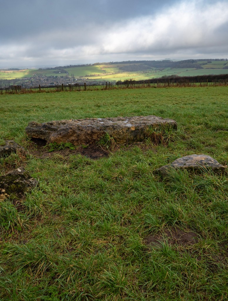
There are a series of large linear earthworks that run from east of west across John Cross Rigg that Archaeologist Blaise Vyner has classified as a Cross-Ridge boundary. The chronology of the earthworks is not known. With the vegetation removed it is possible to see some of the structures incorporated into these massive earthworks including a short section of stone-covered trackway leading north from a stone setting in a gap between the dykes. It will be interesting to see the results of any post-fire archaeological investigations that take place over the coming months.
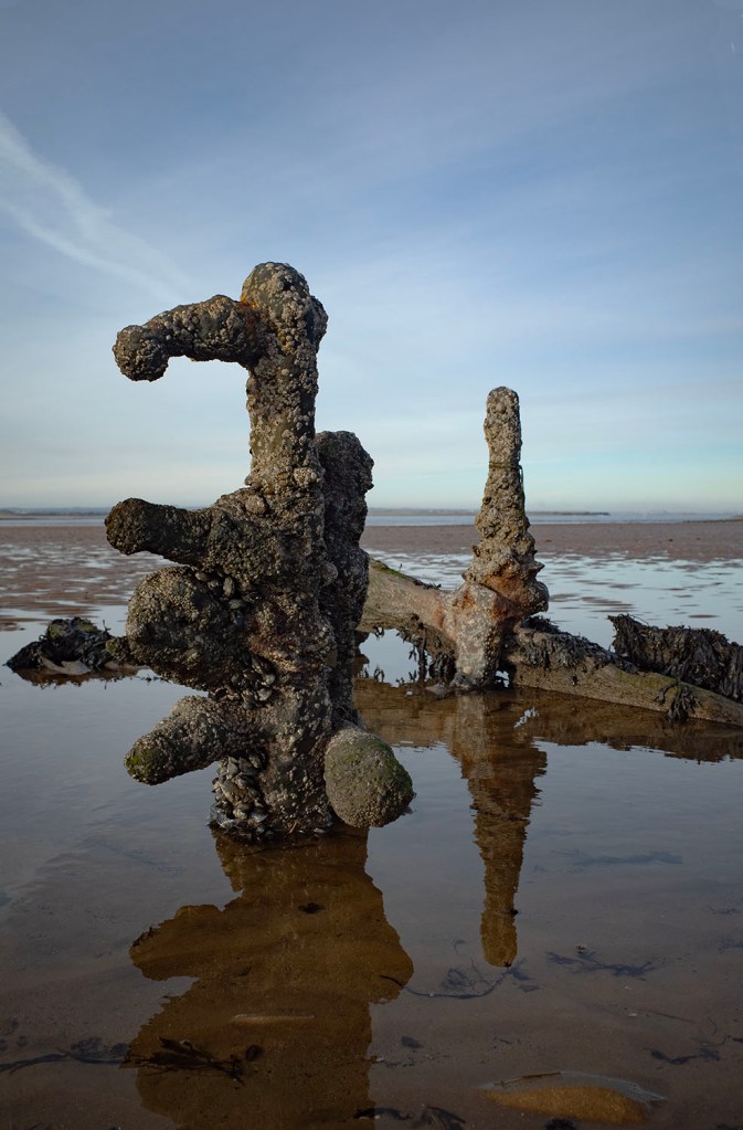
I was relieved to see that the standing stones on the western margin of the boundary were left unharmed by the fire. The large stone is known as the Old Wife’s Neck and is a particular favourite of mine.

If you decide to take a walk onto any of the fire damaged areas it’s important to take note of any safety notices regarding the possibility of unexploded munitions. I would also suggest that you wear a decent pair of wellys. A number of the existing paths have been damaged by the digging of the fire breaks which has also led to the creation of some quite swampy areas and deep pools of water.
Resources
Cross Ridge Boundaries on Fylingdales Moor. Blaise Vyner. Prehistoric Yorkshire 58. 2021
Map – National Library of Scotland


“Neere unto Dobham (the Porte of the Mouth of the Teese) the shores lyes flatt, where a shelf of sand raised above the highe water marke, entertaines an infynite number of sea-fowle, which laye theyr egges heere and there scatteringlie in such sorte, that in tyme of breedige one can hardly sett his foote so warylye, that he spoyle not many of theyr nests. These curious builders may furnish themselves with a choice of shells and particoloured stones fytt for the makinge of artifyciall works: and as the tyde comes in, yt bringethe a small wash of sea-cole, which is imployed to the makinge of salte and fuell of the poore fisher townes adjoininge: the oylie sulphurousness being mixed with the salte of the sea as yt floweth, and consequently hard to take fyre”
Attributed to Sir Charles Turner in History of Cleveland by the Rev John Graves published in 1808.
At home I have a shelf that is slowly filling-up with the wonderful, affordable, documentary photography booklets published by Cafe Royal Books. This pair are the most recent additions. I’d highly recommend that you check out their website.

New Years Day 2026
Ynys Môn


While visiting family in North Wales I managed to steal away to Anglesey for a few hours to visit the Catholic church of Our Lady Star of the Sea and Saint Winefride at Amlwch.


The concrete and brick built church was designed by in 1932 by Giuseppe Rinvolucri, an Italian who lived in Conwy. The Futurist design resembles an upturned boat complete with portholes, a nod to Amlwch’s maritime heritage, it is an extraordinary and unique building.

The church was locked but I was able to peer inside through the small glass panels in the main door. I expected the interior to be be quite dark but the lovely glass panels in the roof cast a beautiful ethereal light into the building, even on an overcast day.

It’s also worth noting that Mr. Ian Fraser Kilmister, Lemmy to you and me, went to senior school in Amlwch. It will be of no surprise to anyone that Lemmy and his school parted ways before he could finish his final year.
Saint Winefride (Winifred in English) was a 7th century Saint who lived in North Wales. Winefride’s legend varies but the gist of it is, that a prince called Caredoc tried to seduce her. Winefried refused his advances and tried to escape from him. The prince pursued her and cut off her head. Fortunately for Winefride her uncle, a local saint called Beuno, managed to place her head back onto her body and use his miraculous power to return her to life. Winefride later became a nun and abbess at Gwytherin in Denbighshire.

A spring arose at the spot where Winefride’s head hit the ground. A shrine was built around the spring and the water is said to have powerful healing properties. The shrine is in the aptly named town of Holywell and is said to be the oldest site of continuous Christian pilgrimage in Britain.
Winefride is the patron saint against unwanted advances.
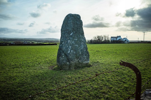
Whilst in the area I tried to visit the Meini Hirion standing stones but had forgotten my map, I ended up driving along a network of ever narrowing lanes until I gave up my search. All was not lost though, I stopped to have a look at this lovely 3m tall standing stone which sits in a field just beside the A5025. It is known as The Soar Stone or Llanfaethlu Standing Stone.
Image of St. Winefride By Amanda Slater from Coventry, West Midlands, UK – Shrewsbury Cathedral, CC BY-SA 2.0, https://commons.wikimedia.org/w/index.php?curid=64158518

In keeping with my current location Blwyddyn Newydd Dda and thanks for visiting my blog.
My goals for 2026 are pretty much the same as 2025 – stay positive, remain curious, keep it a little weird.
Gavin
On a day cast in mist and fog my chances of seeing the sun or moon were pretty much nil so I set myself the task of seeking-out something that I had not seen before.
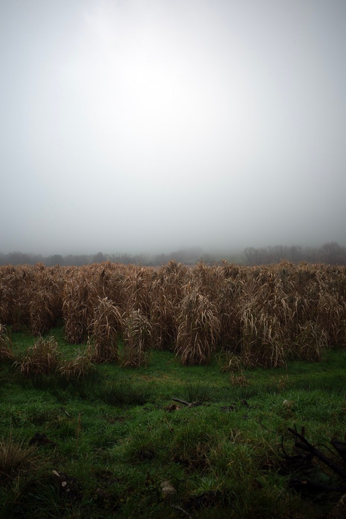
Parking-up I was intrigued by these crops, I think that they may be maize but I’m not sure. (see comments below)

I head into the forest and find the track that runs parallel to the field wall. Keeping my feet on the track becomes a little difficult as motorcyclists have reduced it in parts to a narrow muddy channel.
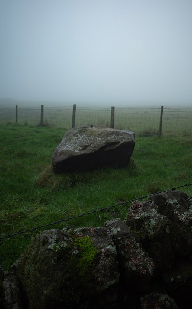
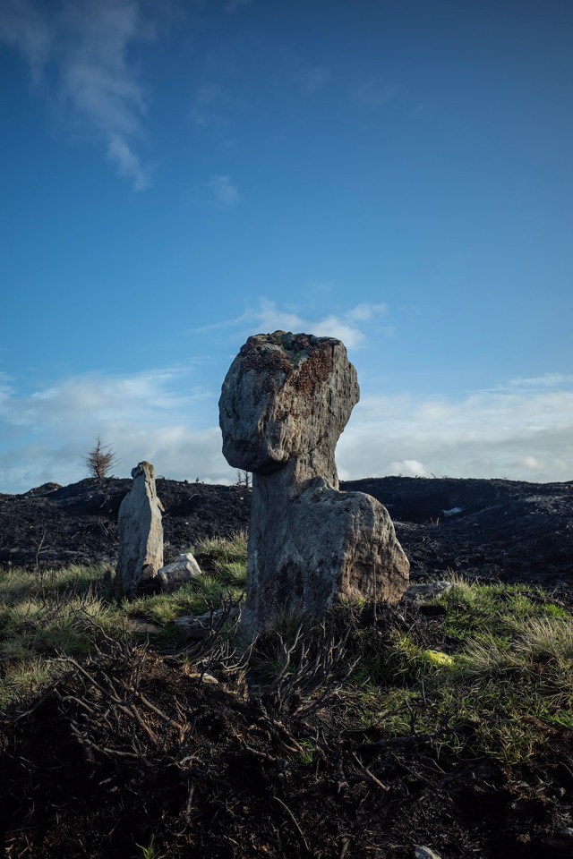
A large boulder sitting in a field means that I’m getting close to the circle.

The stones appear out of the mist, it’s a lovely ruined ring. It’s been a few years since I was last here as I don’t get around this area very often. I think that perhaps next year I’ll spend a little time exploring this corner of North Yorkshire.

I hang around the stones for a while enjoying the misty stillness. Apart from a dog barking in the distance everything is quiet. I kick over a few molehills in remembrance of a friend who, in search of flint artifacts, wouldn’t leave a molehill untouched.

Farewell to the fields, it’s time to head into the forest to seek out a cup and ring stone. I’ve not visited this stone before and only have a rough description of its location. I blunder into the forest and start searching.
Forestry plantations are not designed to be walked, they are planted to be worked by large machines so are not ideal places for wandering, they are also not ideal for wildlife, the forest is silent.

I find a tree that has recently been uprooted and spend some time looking around the newly-formed pit and the debris attached to the exposed roots.
Just across from the fallen tree I notice a patch of needles that have been carefully cleared around a stone. I walk over to it and there it is, a beautiful cup and ring carving. There is a decayed but recognisable Brigid’s cross lying beside the stone.

All things considered, the carving is in fairly good condition. There is a large prehistoric cairnfield buried beneath this part of the forest. It is thought that this stone, like many of the carved stones on nearby Fylingdales Moor, may be associated with these monuments.

On leaving the cup and ring stone I discover that my random wandering has left me a bit disorientated. After walking for a while I can see the forest edge but my path is blocked by a dense wall of young conifers.

I eventually find a rough track which leads to one of the wide forest roads. Wandering along the road I encounter a dead birch tree. All that remains of the tree is the trunk which is studded with bracket fungi, I have never seen so many on one tree.

Continuing along the forest road I’m still not too sure of where I am. I come to a footpath sign which I follow, after a while I begin to hear the noise of traffic so am confident that this is the right direction. This was not the path that I was on earlier but it brings me out onto the road quite close to where I parked. I’m wet, muddy and wearing a big grin.

