

On a dark late December winter night the United States military launched its secretive X-37B spaceplane atop a Falcon 9 heavy rocket from Kennedy Space Center. After watching the rocket slip from sight and the side boosters return nothing was seen from the spaceplane until the night of February 7, 2024 when amateur satellite observer Tomi Simola found something unusual, read his story below…
Read more: The Hunt for OTV-7Into the Dark
At 01:07 UTC December 29, 2023, the US Space Force (USSF) launched their latest X-37B spaceplane mission referred to at Orbital Test Vehicle (OTV) 7 into a highly classified secret orbit.

Unlike earlier missions this launch was not targeting a low Earth orbit (LEO). The limited details shared to the public in Notice To Airmen (NOTAMs) revealed the spaceplane was likely targeting a high Earth orbit (HEO). Dr. Marco Langbroek conducted an analysis of the NOTAM information and shared a plausible trajectory for OTV-7.
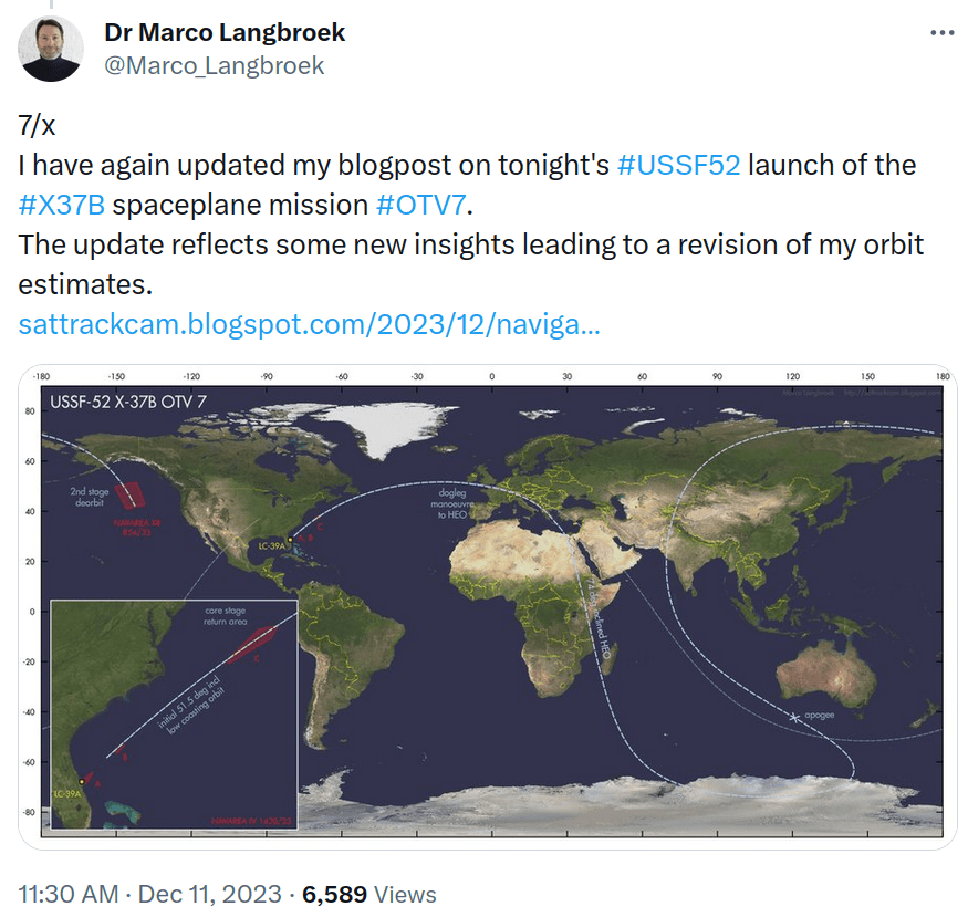
Unfortunately, the time of the launch placed most of the trajectory in Earth’s shadow hiding the spaceplane from view during most of its initial coast orbit and while climbing to apogee it would be lost in the glare of the Sun during daylight.
To make the search more challenging X-37B’s are not known to emit on traditional Tracking Telemetry and Control (TT&C) radio frequency bands and likely use the National Reconnaissance Office’s (NRO) classified Satellite Data Service (SDS) and inter-satellite communications links making it exceeding difficult to track emissions from the spaceplane.
One thing we did have going for us to search for on radio in the dark and later in the glare of the Sun was the final stage of the Falcon 9 Heavy. Given the NOTAMs revealed the rocket stage would be de-orbited over the northern Pacific Ocean thus its mission would likely carry on to at least apogee where it would conduct a de-orbit burn to lower its perigee to below the Earth’s surface to safely de-orbit the stage in the remote ocean area noted on the NOTAM.
Using Federal Communications Commission (FCC) filings we found the particular paperwork for the USSF-52 launch as submitted by SpaceX and knew that the final stage rocket should be emitting on 2232.5, 2247.5, 2255.5 and/or 2272.5MHz.
A group of amateur satellite trackers in Europe and western Australia where organized in an attempt to gather radio data from the Falcon 9’s final stage in an attempt to confirm the actual trajectory of the OTV-7 through this indirect means and hopefully allow for its optical recovery later.

The observer in western Australia maintained vigilance for the entire expected pass of OTV-7 and its respective rocket booster. Guidance was provided to the station to conduct scans of the clear sky from 2200-2300MHz from the site using their 1m dish antenna in an effort to find the rocket booster’s emissions on S-band. We heard many signals from many other missions but nothing form OTV-7’s rocket booster. Therefore, either the rocket booster wasn’t emitting, which would be highly unlikely considering past observing experience or the trajectory guess for OTV-7 was not accurate enough to place the rocket booster in the sky above the observer in western Australia.
To Planar Scan or Stare into Space…?
It seemed like our only chance to find OTV-7 using Marco Langbroek’s reasonable analysis of NOTAM data had resulted in failure and most likely a long search would need to be performed to find OTV-7. Two possible strategies to find OTV-7 could have been reasonably considered. One, a planar search which assumes OTV-7 was on the orbital plane Marco’s trajectory stated but it was not in the location in the plane we thought. Two, multiple observers could just stare into space and with patience OTV-7 would pass sooner or most likely later through the field of view of someone.
What is a planar search? A satellite once launched into space is in a fixed plane with respect to the stars and it will stay in that orbital plane for all practical purposes unless something adds or removes energy from the object. The effects of atmospheric drag ,solar radiation pressure, venting etc. can cause the spacecraft’s position within an orbital plane to change over time creating uncertainty of where within the orbital plane the satellite is. To recover an object in a known orbital plane one can search the plane by scanning along it for a prolonged period of time and eventually you will find your wayward satellite. However, this assumes you know the orbital plane correctly.
In our radio search for the final rocket stage which should have been very close to OTV-7, we actually compensated for this by conducting a broader search of the track and sky for some hours and would have likely found the rocket’s emissions had the orbital plane guess been close. Another factor is the timing of arriving in the orbit was fairly constrained limiting the search area along the orbit plane. This left us to conclude that OTV-7 was most likely not in the orbital plane Marco’s analysis suggested. Thus an planar search of the plane Marco suggested was likely going to be very laborious and not result in recovering OTV-7.

Based on what we knew, it was agreed that staring into space may be the best strategy. You may be wondering and rightfully point out that space is pretty vast and staring at a fixed small spot may never produce results. It’s counter-intuitive but the fact is a satellite is in a fixed orbit. In this case we roughly knew the orbital geometry of our target and had a pretty good idea that if we aimed a camera at an intelligently chosen fixed spot and waited long enough the satellite would pass through and we would know it was our target because almost all other objects on orbit are known and catalogued or would be in different orbits and could be excluded.

This is what Tomi Simola did to find OTV-7, he setup a light sensitive camera and connected it to a computer to record the results and excluded every object that passed through his field of view for literally weeks until an unidentified object passed through the field of view that matched OTV-7’s characteristics.
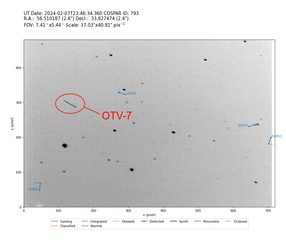
On the night of February 7, 2024, Tomi Simola recovered OTV-7 and made these observations with his staring camera. Once you have even a limited set of short arc observations you can start to generate orbital elements from the data and start to narrow down the identity of the object. After consulting Mike McCants an expert on classified objects on orbit the identity was quickly firmed up as the orbital data came in on successive nights.
It turned out that our assumption that OTV-7 was in a different orbital plane than Marco’s reasoned guess was correct. Below you can see the dramatic difference in the sky track from the observer in western Australia for OTV-7. Much of the track was obscured by trees and other obstacles at the ground station. OTV-7 quickly passed through the ground station’s clear area of sky spent most of the pass low on the south eastern horizon obscured by trees and then as it descended from apogee passed quickly through the observable sky and disappeared…


For the record here are the initial guess TLE vs. the TLE developed from Tomi Simola’s observations of OTV-7 after it was recovered.
USSF-52 OTV 7 for launch on 29 Dec 2023 01:07:00 UTC
1 70000U 23999A 23363.06545139 .00000000 00000-0 00000-0 0 02
2 70000 074.0000 341.4480 7418186 136.2072 360.0000 02.14201823 02

OTV 7
1 58666U 23210A 24039.74420665 0.00000000 00000-0 00000-0 0 04
2 58666 59.1161 4.8483 7418435 167.3793 193.0310 2.07574710 01
An Interview with Tomi Simola on Finding OTV-7
Scott Tilley – Can you describe your observing strategy you used to recover OTV7?
Tomi Simola – Stare long enough and it will pass your Field-of-view!
Earlier I have been pointing my camera at different parts of the sky, depending on the object or area of interest. Because OTV-7 has gained great interest in the satellite watching and space technology community I elected to keep the camera stationary. Early orbital predictions showed that OTV-7 will eventually pass the FOV! As you pointed out (and it makes perfect sense), there is no point to chase a satellite when you don’t know where it is!
Scott Tilley – Can you tell us more about how you and Mike McCants came to the conclusion that the object you observed was OTV7?
Tomi Simola – After I posted my first observations to Seesat-L on February 8, Mike McCants emailed me three hours later with orbital elements for “Unknown 020724”. He could not match it with anything in his catalogues. He reckoned “it was a small piece of space debris catching sunlight just right.”
I respectfully disagreed, explaining that visually the UNID was steady over the whole pass and “eyeball” magnitude similar to large USA 144 Deb (25746 / 99028C), which has passed a couple of times on a similar distance.
Next night I observed it again and very close to Mike’s earlier prediction. He told me that I’ve found the OTV-7!
Scott Tilley – Can you describe your observing equipment. What kind of camera, lens and software are you using?
Tomi Simola – I use the Watec 902H Ultimate analog video camera with a Chinese TTArtisan 50mm f1.2 lens. There is a 3D printed adapter in between. The lens was a lucky find for only 100 euros!


The software is Cees Bassa’s STVID and SATTOOLS. I have the camera in an IP68 camera housing with a servo driven sunshield in front of the lens. Separate mini PC has STVID doing the capture to a NAS storage in my network. A virtual machine has a STVID and SATTOOLS installed and I use it for processing the observations.
Scott Tilley – How did you feel when you first noticed the unidentified satellite in your data?
Tomi Simola – I was browsing the images that STVID had tagged as UNID. There was one set of images (20 or so) with an object with a rather short trail, meaning it was in a higher orbit. And while scrolling the images back and front I noticed the object was “accelerating”! The trail got longer (almost doubled) at the end of the set of images! Then I knew that this was something different!
My amateurish initial analysis for a circular orbit showed it in 56.5518 inclination, 6.6 revs/day. That inclination didn’t sound like Dr Marco Langbroek’s pre-launch prediction of 74 degrees. 6.6 revolutions per day was too much for a Molniya kind of orbit. I stated my doubts in an email to Seesat-L.
Scott Tilley – When did you know that you had found OTV7? How did that feel?
Tomi Simola – After Mike McCants email where he told me the UNID was OTV-7! I might have done a wild, but private “goal celebration”!
Scott Tilley – Can you tell us about your observing site and how it makes satellite observing unique? I.e. your northern latitude and how that affects satellite illumination.
Tomi Simola – My observing site is in my south facing backyard. But there is an area where I can set up my camera and point it over the neighbours roof, pointing low at the Northern sky. Area of the sky is busy with NOSS satellites which are very predictable and they are good targets to practice observations!
My latitude is 60 North, so some satellites are more visible earlier in the spring / later in the autumn, than for those in lower latitudes.
The site is very close to an international airport, but that has no great effect in my observations.
Scott Tilley – In this process of building an observing station and operating it what have you learned and what are your next steps?
Tomi Simola – I was not that much interested in visual satellite observing until two years ago, when I found the Watec camera for a very good price! Cees Bassa’s STVID was at that time getting rapid updates. Then I started to read tutorials from www.satobs.org.
I have done some RF observations with Bassa’s STRF (interest in this was sparked by Scott Tilley’s recovery of IMAGE in 2018), but the visual side was something different. SATTOOLS and STVID are very powerful software, but learning curve is…”steepish” – especially when one has no prior experience in visual satellite tracking!
Tutorials, articles and members of the Seesat-L have helped me to understand a bit better orbital dynamics and therefore I can pre-analyze my observations a bit better now. But there is so much more in orbital dynamics, visual tracking, that only way is forward! Interesting hobby that I never thought I’d get into!
More technical side, I have to improve the Wife-Acceptance-Factor of the camera setup. Also, a motorized mount would be nice in winter time!
Scott Tilley – Why do you look up and observe the sky to monitor satellites?
Tomi Simola – My interest in space flights and satellites was sparked when I was a small boy. I was living in a small village, far from the nearest city, with a stunning night sky! Moving stars in the sky were quickly explained as satellites.
The school library had lots of old books and my favourites were translated versions of “Die Mondlandung / Moon landing, 1969”, by Herbert J. Pichler and “Man and space, (Life science library), 1972” by Arthur C. Clarke. I have read these tens of times! I later acquired these books for my ever growing space library!
In my teens I received weather satellite pictures from NOAA and old Meteor satellites and kosmonauts talking with Moscow from MIR.
Satellites are fascinating! They are so close, just 200-300 km away, but getting there requires the smartest minds on the planet!
Spaceflights were for a long time only for superpowers and government backed institutions! They were rather rare occasions. Now, when technological advancements have brought satellites to the masses (you can almost literally buy your own satellite!), the “saturation” of the lower Earth orbit is getting more serious. I think satellite collisions are still rare, but astronomers using the whole electromagnetic spectrum (from DC to daylight and beyond) are getting frustrated with RF and visual noise in their data! Future space companies should have more responsibility to keep near space clean.
Amateur observers, not only for classified payloads, have an important task to bring these problems to the public and more importantly, to lawmakers! Good example is BLUEWALKER 3, which has a very large and visible antenna and dubious RF characteristics!
Conclusion
Once again amateur satellite observers with modest means and lots of patience find a classified object in space. We hope that sharing this story inspires others to look up and ensure the transparency in the use of space by all nations.


 Riddles in the Sky