Posts Tagged ‘artwork’

Gafton City Map

May 25, 2016

Gafton-map

This city map from an old DragonQuest campaign recently turned up during some sorting.  It was a preliminary sketch, and far from completely worked out.  A few key locations are identified, and some general notes about other areas are pencilled in.

The Castle sits atop a rocky hill, commanding the highest ground in the area, and two lower hills and the intervening valleys make up the terrain occupied by the city. Wider, longer hachures are to indicate hills, and the shorter, tighter ones are more cliff-like.  Two large bridges have been built to span the valleys and connect other parts of the city to the center.

Gafton is a city with a population of around 24,000 located in a high plains/mountain foothills setting (think of someplace sort of like Denver CO).  It is one of a number of city-states in the region. There are rivalries and alliances between these city-states which keep the area politically turbulent.

Populations tend to cluster more than typical because the outlying areas are very wild and hazardous to travel through.  Dangerous beasts and great monsters are prevalent, as well as the numerous mercenary companies who cross the region in service to the princes of the cities.

Intersection J

May 4, 2016

encounterj-3-14-2016

Experimenting with some alternative textures for the cavern walls and a bit more interesting layout with the bridge and stairways in the Sand Cavern.

This is a bit more constrained in the ways the two passages are connected, with the Sand Cavern being the nexus to get from one passage to the other (unless you locate the secret passage connecting the two side rooms).  The rooms are almost all subsidiary to the passages, rather than being interconnected in the way some other Intersections have been.

Intersection I

April 20, 2016

encounteri-3-14-2016

There are two primary lines in this intersection, but unlike some of the others, this doesn’t have multiple connections between different paths.  To get from one side to the other, you have to go through the two locked rooms on this one.  There are a few side rooms, and one complex of rooms off the passages, rather than being connected to other parts.

These maps I’ve been making with very little post-processing.  Generally, these are just pencilled and then inked and then scanned and posted, so some of the warts and flaws show from time to time.  But, overall, they seem to be working well.  I’m still very interested in hearing about anyone using any of these in actual play.

Trollbrucke – Foundations

March 30, 2016

map16-0330draft

This is mostly done now.  There are a few final touches that need to be added in, and the upper layers haven’t been drawn, yet.  But this gives a pretty good sense of where I’m headed with this project.

I thought the idea was pretty great, although mostly just a throwaway, initially.  But I’ve spent too much time fussing over it, and I think it’s lost some of the original energy.

There is already a section above this, which is well underway, with the surface and the actual bridge itself.  By implication, there could be a couple more sections, with the two ends of the bridge off to either side.  There are also at least two more implied underground sections, with the tunnel leading off to the right and the stairway leading even deeper.  Those may remain unknown, though.  Too many things I don’t like in this, although it was fun to try.

Streithnaught’s Basement

March 25, 2016

map16-0326

After some recent discussion about things DragonQuest, it occurred to me that I haven’t done nearly enough hex-grid maps.  So this is a first step in remedying that deficiency.

I think that the under-caverns read well enough that a GM could readily use this without having to do lots of figuring out of what is where, and what the map contains.

If there’s interest, this could turn into another Un-Furnished Dungeon, though being hex-gridded rather than rectilinear probably dooms it from the start.  So I’m not going to go into a lot of description of the particular features here, for the most part.  But there are a few features that probably bear a little explaining.

  • The spiral stair at the center of the large cavern leads up to the building above.  The ceiling of the cavern is roughly 20′ high, so the whole stair is more than 40′ up into the building.
  • The feature close by the stair (about 5 o’clock from the stair, 1 hex south-east) is a depression or ditch in the floor of the cavern that connects to the tunnel leading away to the right.  The opening into the tunnel is only about 3′-4′ tall, though it gets taller as it slopes down away from the cavern.  (The stippling pattern in the cavern areas and the lines indicating the slope read as similar values.)
  • Several decoratively carved openings line the north-east hallway (upper right)
  • The rubble at the upper left can be treated as solid wall, if the GM wants to keep this as a self-contained location, or the passage beyond may connect to something else, if it’s to be part of a larger setting.  The stones could also be blocking the passage beyond, but the PCs might discover that there is a way to get through if they move enough of the stones and debris away.
  • There is a floor trap in the secret hallway at the far right side which falls about 15 feet to the cavern room below.

As is the case with most of my maps, feel free to use this for any non-commercial purpose (with attribution).  You can also contact me if you’d like to use any of my works for a commercial project.

Intersection G

March 23, 2016

encounterg-3-14-2016

A more rectilinear kind of intersection with a large number of connections.  There are 8 different hallways connecting to this intersection (2 per side).  The very gridded origin of this intersection is quite clear in the alignment of each pair of hallways, which line up from one side to the other, but which have to pass through the complex of rooms to get from one side to the other.

It wasn’t something I was particularly paying attention to as I drew this one (obviously), but only one of the eight paths into this intersection presents a choice of two doors; five of the rest are halls that immediately terminate with a door.  I’ll have to pay more careful attention to things like that in the future.


Intersection F

March 22, 2016

encounterF-2016-02-06

Intersection F is less “intersectiony” than a couple of the previous ones, a little more of a knot, with intertwining ways to get from one side to another.  But still, it has the same general organizing idea of an area where several paths off in different directions are interconnected.

This does not have stairs or anything to graphically represent a level change, but it feels to me as though the right side should be higher than the left, and maybe some of the hallways would actually be ramped downward to accommodate the level change.


Kumursko Tunnels

March 3, 2016

map16-0303

Well, obviously, the character of the walls was the thing for this one.

At first, I thought it was going to have several states to it, like old etchings.  This is the “second state” (the earlier being just a general poche for the solid areas without any particular density close to the walls.  But, it seems done, and I don’t feel compelled to mess with it more at this point, so I’m calling it done.

This particular map has several entrance points, which seems entirely appropriate for its wandering, sprawling style.  The character of the walls suggests nibbling or biting out pieces to clear the openings.  It could also work as a series of islands in a wet swamp.

As is the case with most of my maps, feel free to use this for any non-commercial purpose (with attribution), or contact me if you’d like to use this on a commercial project.


Two Views Mapping the Space

February 29, 2016

When I started on the recent military perspective map, I just threw blocks at it and let things go where they went.  There was not a planned organization or a backstory to drive it.  The result, so far, has been interesting, though perhaps difficult to read.  The pen shading test I did the other day was just to see if that might help it read better than it did initially.

But, in order to make it playable, I thought that a conventional, top-down style map would be useful for players and GMs to help keep track of where things are located.  These two maps are of the same space, then.  One is the perspective map that helps indicate the (many) different levels in this.  The other is the conventional plan view.

persp+plan

This is still work-in-progress, with more work (including the previously proposed shading ideas, and some coloration to aid in distinguishing levels) to come.  But this is far enough along now that it’s worth sharing at this point.

Intersection E

February 24, 2016

encounterE-2016-02-06

This is Intersection E from the intersections series.  Originally the idea for these was that they would be really quick maps (the first couple were only about an hour each to draw), and I’d post one a week, although I’m behind on that count.  But, if the Intersections are a year-long project, and I’m giving them letter names, then that would imply about one every other week, and I’m ahead of schedule in that case.

This set of passages comes to a common meeting chamber almost like wires to a chip.  There are four connections (one off each edge of the page), and the other two doors from the central meeting area just lead to simple rooms.


More Hand Drafted Patterns

February 23, 2016

This is not as extensive as the geologic one, but is certainly another nice set of hand drafted patterns.  This is also the kind of thing that I loved in drawings I found in books; materials keys that explained a building section or a diagram.  And this is also part of the inspiration for the kinds of maps and dungeons I’m drawing now.

76839_buildmatsym_md[1]

The website where I found this has both a smaller- and a larger-size version of this image.  {NOTE: The site is a part of the Florida Center for Instructional Technology, and they claim a copyright on this material, though they do have an educational use permission (ClipArt ETC Free Classroom License).

I think my use here qualifies (though maybe only marginally) as educational, since I’m trying to show you all this style of drawing materials.  If this post gets taken down in the future, though, that’ll most likely be the source of the problem.}  There are a lot of other clip art pieces in their collection, which might be inspirational to you, as well.  And I’d be certain to avoid using anything you find there commercially, even if I am dubious about the solidity of their copyright claim on works over 100 years old.

Works in Progress

February 19, 2016

Here are updates on several different things for the past couple weeks, including a work-in-progress map, the Exquisite Corpse CITY project, and a couple of DragonQuest-related items.


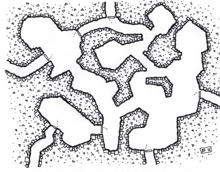
The map is a progress shot of another “military perspective” map.  This was trying out a shading (using a gel ballpoint pen; not how the finished version will be done. This was just testing on a photocopy of the map).  The colored shading seems to help with reading it more clearly (and shadows on the ground may help, as well).  I’m thinking about also making a simple, standard overhead view map of this same complex, to make it easier for a GM to make notes and keep track of where the characters and the opposition are.

progress2 draft

Would this be good as a future Un-Furnished Dungeon? Or, the second map could be a Patreon supporter premium, if I got that up and running.  (Some other thoughts on Patreon below.)


The Exquisite Corpse City project is still under way, and we seem to be making a little progress.  I’ve handed off sections to a couple more people this weekend, and the number of available slots will keep increasing as more pieces are done and the city grows, and there are more edges to add on to.  I’ve posted a glimpse of the 3/4 completed city center, to give a sense of the variety of styles that are going to be in this from the outset.  For those of you who aren’t following the Exquisite Corpse CITY Google Group, here this is:

EC-city-prev

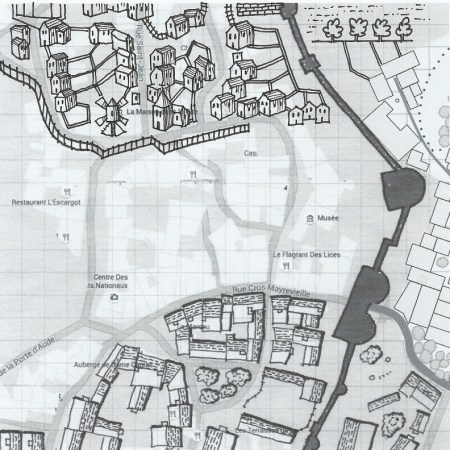
I really like the very different styles that are in this already.

The start was slow, because there are only 4 sides to the initial starting square.  With 3 of those sides now extended, there are now 5 openings, and another 3 will come open when that 4th side is done.  And as some of those get finished, even more openings become available.

This Exquisite Corpse is a little more difficult to manage, since part of the process is to have each artist go back and add in some buildings in their style to the section that they built from, so the seams in the city should be a bit less straight line.  That requires everyone to work on top of everyone else’s drawings, so that is causing more complication, but I think it’ll turn out well in the end.


The DragonQuest adventure (Wilderness of Ordurak) was subject of some recent discussion on the DragonQuest RPG group.  We are really hoping that it is going to be done in the next couple months, along with the revised version of The Water Works adventure and the Poor Brendan’s Almanac supplement.

If Patreon had been around a few years ago, that would’ve been a much better model to work from.  And, I’ve been thinking about starting a Patreon for the maps I’ve been making, although there are many other gaming map makers out there, and I’m not sure if there would be interest in supporting my work.  (If you would seriously be interested, though, let me know.  If there are at least a few potential supporters, I’d be more tempted to start something like that up.)

The other thing that would make a lot of sense as a Patreon project would be a re-write of the DragonQuest rules (aka Open DQ).  This is an idea that’s been kicking around, though without much interest behind it, for quite a while.  Like other OSR retro-clones, it would be a compatible re-write of the rules to duplicate the functionality of the original SPI game, but with new (and in some cases updated) re-writing so that it was not just a transcription of the existing rules.  Each new rule section completed could be an individual goal in the Patreon system, and delivering one or two a month might be reasonable, and no one would be paying anything until something was delivered each time.

Finishing the Wilderness… is the first task.  But after that, is there more support for a DQ-oriented Patreon, or for a mapping-oriented one?


Intersection D

February 17, 2016

encounterD-2016-02-06

The initial idea for Intersection D was to make it a nexus between three different pairs of passageways.  These could be three different underground systems, or just a common meeting area within a single, larger complex.

The ritual nature of the central meeting area suggests a possibility of it being a common meeting point for the three areas, where some sort of group activity might be carried out.  The nearby chambers off each set of paths could serve as waiting areas for members of each of the different regional factions, and the side chambers of the meeting nexus itself (leading off from the central room to the lower left) might be for some group purpose at these gatherings.

Intersection C

February 10, 2016

encounterC-2016-02-06

This is another in the current series of smaller maps for connecting dungeons or staging encounters.

This one also incorporates some level changes (with the south and west passageways being higher, and the north and east being lower than the rest of this intersection area), so it could be used to go from one level to the next, as well as just for connecting between other sections.  (And, I suppose, if you don’t want to bother with the level changes, it would be easy enough just to ignore them and use this as a flat connector between sections.)


Intersection A

January 5, 2016

encounterB-2015-12-14

This is the first of an occasional series.  Rather than making a complete dungeon map, this is just a fragment that could be part of a larger complex.  It could serve as an encounter location or be used to connect between two otherwise unrelated maps.

An Oldschool Kind of Map

December 30, 2015

Here’s an old school kind of map for any sort of impromptu weekend dungeoneering hijinks you might need a map for.

postmap34-b1230map

This is a mid-level dungeon, with stairs leading down from above (near the waterfall pool, lower left) and further into the depths (flanking the waterfall at the end of the stream, lower right).

Overall, this is far from a beautiful map, and it was done as just a fast throwaway, but there are a couple interesting bits you might like to use in maps of your own.  The watercourse is kinda interesting, but doesn’t quite work.

Since this was scanned in color – to get the blue of the water to show – I had expected that the grid might show up, as well.  It’s interesting that it didn’t show up in the scan, but the phonecam sees it just fine.

maplook

Merry New Year, all!  I’ll try to have something good queued up for Friday, again.

As usual, feel free to use for any non-commercial purpose, or contact me if you’d like to use this on a commercial project.

Crypt of the Tetris-Lords – pt 1

December 25, 2015

Some of the side passages and service areas for the larger complex known as the Crypt of the Tetris-Lords (which is largely in the areas following the wider hallways off to the top and right from this section).   Entrance is from the passageway coming in at the bottom.

Capture-mapb1223

An early WIP post of this was jokingly titled “Crypt of the Tetris-Lords,” so I’ll stick with that.  The image was scanned extra light in order to minimize the layout grid.  I suppose it could be nice to keep the squares for counting out distances, but it reads really nicely without them, too.  And, if you want to actually use this for a game, I think it’s tetris-y enough you can figure out most distances and dimensions pretty readily.

After posting the last map in this style, I learned that it is also referred to as “military projection.” It’s probably more correct to call this oblique projection (and you can make an accurate flat map from this by tracing the walls and edges).

As usual, feel free to use for any non-commercial purpose, or contact me if you’d like to use this on a commercial project.

Drevansic Warrens

December 18, 2015

It is said that there are seven levels to the underground complex known as the Drevansic Warrens, but those are only tales from an earlier time.  Clethus Strongbow reported that he had been to three levels, and then never returned while exploring for a fourth.postmap30-b1202map

A weird, twisting mess of odd shaped rooms and bending hallways.  This is principally an intermediate level, to be used with a larger complex, with stairs leading both up and down.

As usual, feel free to use for any non-commercial purpose, or contact me if you’d like to use this on a commercial project.

Table of Patterns for Rock

December 15, 2015

Here’s one of the kinds of things I loved coming across in books when I was a kid.  This is probably a part of why I love drawing dungeons like I do, and that’s why I’m sharing it here.

plate_iii_lrg

I think this is a great resource.  The full size plate is a thing of beauty.  This came from the Gutenberg project, so it is a work in the public domain, and I’m happy to see it shared widely.

Already, this has figured into a couple of the maps I’ve posted (whether to good effect or not is a separate question), and I hope to do more from this chart (maybe eventually at least one of each, but there are no promises about that).

For reference, the kind of hatch that I do most often (and that Dyson Logos popularized) is #58, “Massive igneous rock,” but there are clearly other choices available, if you’re open to mixing it up a bit.

The Sakkiz-Kamar Underhalls

December 8, 2015

An underground complex of 15 rooms, with a central hallway connection.  Stairs shown at the bottom of the map lead up to the main Fortress Sakkiz-Kamar.

postmap32-b1207map

This is an axonometric projection, so all the rooms are the proper size and orientation to one another.  It’s similar to isometric, but here, the walls that should be 90 degrees to one another are 90 degrees, so you can rotate this  halfway and look at it as a plan view.  Distances between places can be measured accurately (as long as you are measuring parallel to the ground plane).

It’s less convoluted than some other dungeons, but in this experiment, I wanted to be sure it would be very readable.  I haven’t really taken full advantage of having the walls show, other than in a couple of rooms (the Large Hall in the middle and the Holding Cell at the far end, as well as a few archways in the corridor), but this is a nice way to show a dungeon, and I will probably do more along these lines.  Next time I do one of these, I should make sure to make the vertical lines non-reproducible; it’ll read much better that way.

As usual, feel free to use for any non-commercial purpose, or contact me if you’d like to use this on a commercial project.


Design a site like this with WordPress.com
Get started