Geospatial search #8239
Geospatial search #8239
Conversation
IQSS/8188-cache_version_differences
|
Per discussion at the DCM that the improved geospatial indexing could be useful independent of adding further geospatial search/display capabilities, I'm moving this PR from draft to review-ready. Not sure what the Rocky shellspec issue is - probably worth re-running the build to see if there's any real issue. |
 pdurbin
left a comment
pdurbin
left a comment
There was a problem hiding this comment.
I added a comment about testing.
| } | ||
| } | ||
|
|
||
| for(String metadataBlockName : metadataBlocksWithValue) { |
There was a problem hiding this comment.
I rewatched Jim's recent "Experimenting with Geospatial indexing" talk ( https://osf.io/84pnw ) and it reminded me that I asked for an test to be added to SearchIT. I still want this and I'm happy to try to add it, if it make sense for me to jump in the code. 😄
Co-authored-by: Philip Durbin <[email protected]>
|
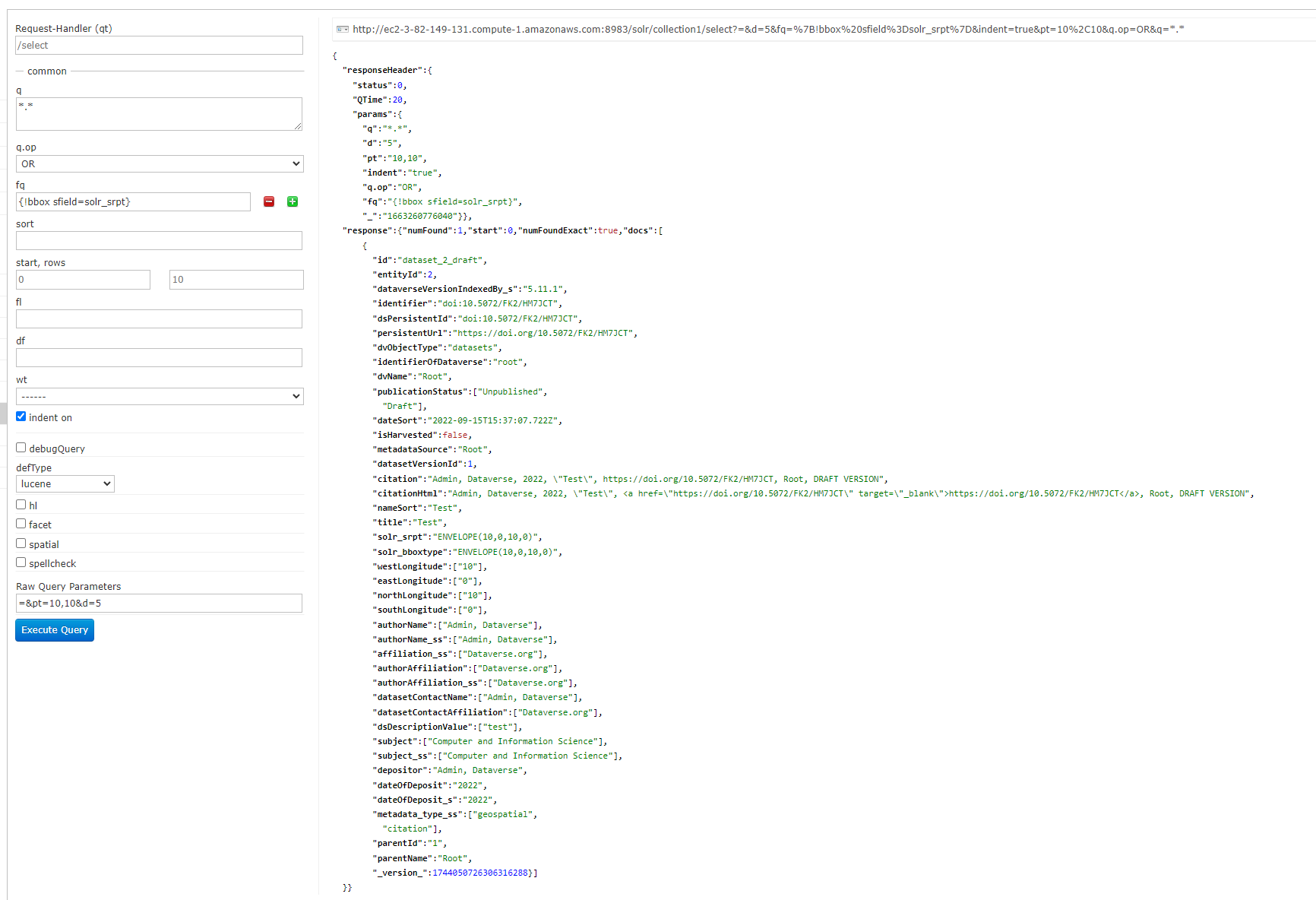
I'm not sure it is possible to make an IT test yet. The solr query that works is as shown: In the UI, I don't think we can submit filterqueries and with the API, you can submit the filter query part but I haven't seen how to send the pt and d parameters yet. If that is possible, an IT test would be straight forward. Otherwise, to test one could use the solr console (dropping the jetty.host-localhost recommended for our solr install to make it accessible, and possibly doing an |
we may want to test for that, but not here.
|
I think the indexing code assumes you're talking about a point (or line) if you leave one coord out so it just replicates the value for the other extreme. So ~feature. |
With only westLongitude added and the other three coordinates left
empty, we were getting the following exception. A null check was added
to prevent this.

Command [DatasetCreate dataset:132] failed: Exception thrown from bean:
javax.ejb.EJBTransactionRolledbackException: Exception thrown from
bean:
org.apache.solr.client.solrj.impl.HttpSolrClient$RemoteSolrException:
Error from server at http://localhost:8983/solr/collection1: ERROR:
[doc=dataset_132_draft] Error adding field
'solr_bboxtype'='ENVELOPE(null,null,null,null)' msg=Unable to parse
shape given formats "lat,lon", "x y" or as WKT because
java.text.ParseException: Expected a number input:
ENVELOPE(null,null,null,null)
|
@qqmyers ok, but I did go ahead and fix a bug when there was only one coordinate: e5187b2 Next up: names. I haven't heard any objections to On the Solr field side we currently have Any reason not to shorted to just I don't know what to say about RPT. SpatialRecursivePrefixTreeFieldType is a mouthful. I'm not in love with Update: In 28215fb I renamed the Solr fields:
Feedback welcome! |
|
I added some error checking and updated the docs based on how the code is now. I talked to @atrisovic about this feature and she immediately asked "Can you sort by distance?" Good question! 😄 I haven't looked into this but maybe? See https://solr.apache.org/guide/8_11/spatial-search.html#distance-sorting-or-boosting-function-queries for I'm also ok with this being API only for now. That's how I wrote it up in the User Guide: https://dataverse-guide--8239.org.readthedocs.build/en/8239/user/find-use-data.html#geospatial-search I'm ready for review. We could keep hacking but there's lots of other stuff to do as well. 😄 I think this is an excellent toehold into geospatial search! |
| junkRadius.then().assertThat() | ||
| .statusCode(BAD_REQUEST.getStatusCode()) | ||
| .body("message", CoreMatchers.equalTo("Non-number radius supplied.")); | ||
|
|
There was a problem hiding this comment.
Should we add a test that's actually a valid lat, long and radius?
or a valid lat with a non-numeric long, etc.?
There was a problem hiding this comment.
In 364e347 I added a test for if lat/long is too big. It turns out Solr provides a pretty useful error, which was already being bubbled up.
I also took a swing at sending a huge value like "99999999999999999999999999999999" to geo_radius but Solr didn't give an error. I dunno, we already test that this number is positive. I say we let the use send bigger and bigger numbers (these are in kilometers). Eventually, they'll figure out they just aren't going to get a geospatial hit. 😄
|
|
||
| } catch (Exception ex) { | ||
| return error(Response.Status.BAD_REQUEST, ex.getLocalizedMessage()); | ||
| } |
There was a problem hiding this comment.
Do we want to catch a nonnumeric exception here and give more feedback?
There was a problem hiding this comment.
Well, getGeoPoint and getGeoRadius will already throw exceptions with feedback about non-numeric values.
For example, if the user does this:
/api/search?q=*&geo_point=41.9580775,-70.6621063&geo_radius=junk
They'll get this error:
{"status":"ERROR","message":"Non-number radius supplied."}
That said, I may not be following the use cases, the concerns. I'm happy to add more tests for these.
 sekmiller
left a comment
sekmiller
left a comment
There was a problem hiding this comment.
Mainly looked at Phil's most recent changes. Looks good, just a couple of suggestions/questions about testing and error handling.
pdurbin
left a comment
There was a problem hiding this comment.
I'm replying to review feedback.
src/main/java/edu/harvard/iq/dataverse/search/IndexServiceBean.java
Outdated
Show resolved
Hide resolved
|
|
||
| } catch (Exception ex) { | ||
| return error(Response.Status.BAD_REQUEST, ex.getLocalizedMessage()); | ||
| } |
There was a problem hiding this comment.
Well, getGeoPoint and getGeoRadius will already throw exceptions with feedback about non-numeric values.
For example, if the user does this:
/api/search?q=*&geo_point=41.9580775,-70.6621063&geo_radius=junk
They'll get this error:
{"status":"ERROR","message":"Non-number radius supplied."}
That said, I may not be following the use cases, the concerns. I'm happy to add more tests for these.
| junkRadius.then().assertThat() | ||
| .statusCode(BAD_REQUEST.getStatusCode()) | ||
| .body("message", CoreMatchers.equalTo("Non-number radius supplied.")); | ||
|
|
There was a problem hiding this comment.
In 364e347 I added a test for if lat/long is too big. It turns out Solr provides a pretty useful error, which was already being bubbled up.
I also took a swing at sending a huge value like "99999999999999999999999999999999" to geo_radius but Solr didn't give an error. I dunno, we already test that this number is positive. I say we let the use send bigger and bigger numbers (these are in kilometers). Eventually, they'll figure out they just aren't going to get a geospatial hit. 😄
|
grooming
|
What this PR does / why we need it: Adds bounding box indexing in preparation for providing geosearch or other features
Which issue(s) this PR closes:
Closes #
Special notes for your reviewer:
Suggestions on how to test this:
Does this PR introduce a user interface change? If mockups are available, please link/include them here:
Is there a release notes update needed for this change?:
Additional documentation: design doc: https://docs.google.com/document/d/1aQCIM6wbAdgMNLTVSUhvuHQKzWDAvQ5XoYGbfint3P4/edit?usp=sharing