NOAA LEO/GEO Flood Mapping Products are Now Available on GNC-A Rebroadcast

Flood_Example_1Flood_Example_2Flood_Example_3Flood_Example_4

united_states_of_america_round_icon_640

Topic: NOAA LEO/GEO Flood Mapping Products are now available on GEONETCast Americas (GNC-A)

Date/Time Issued:  May 13, 2020 1420 UTC

Product(s) or Data Impacted:  n/a

Date/Time of Initial Impact: May 13, 2020

Date/Time of Expected End: n/a

Length of Event:  n/a

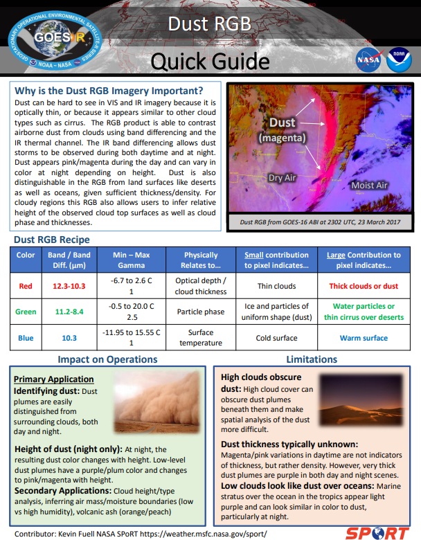
Details/Specifics of Change:  The following NOAA LEO/GEO Flood Mapping Products are now available on GEONETCast Americas (GNC-A) rebroadcast.

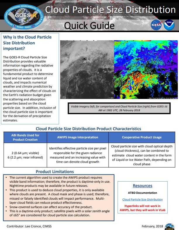
•    GOES-16 & 17 ABI Hourly Composites: The ABI hourly composite has the best time manner in detecting floods as it is updated every hour under cloud free conditions. Information composited hourly for clouds to provide the best and latest cloud free information of flood extent.This can be very helpful for emergency response providing  a low resolution (1-2km) initial flood extent estimate.

•    Joint VIIRS / ABI flood product (daily): The joint VIIRS/ABI flood product combines the clear sky VIIRS and ABI daily composites and represents the best daily cloud-free flood extent. Available at ~0800 UTC daily and is useful for flood extent from the previous day.

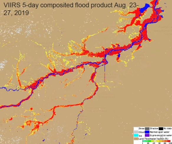
•    Suomi-NPP and NOAA-20 VIIRS 5-day Composite (daily): The 5-day VIIRS composite has the best spatial resolution and provides the maximal cloud-free flood extent during the latest five days. Useful for flood investigation during a major flood event.

The Flood Mapping Products on GNC-A are received on the following ingestion folders:
CIMSS/Flood-ABI: GOES-16 ABI Hourly Composites
Naming convention: River-Flood-ABI_YYYYMMDD_HHMNSS.part00X.force.tif
Note: Parts 1 to 4 (full disk divided in 4 regions).

CIMSS/Flood-Composite: Suomi-NPP and NOAA-20 VIIRS 5-day Composite (daily)
Naming convention: RIVER-FLDglobal-composite_YYYYMMDD.part0XX.tif
Note: Parts 01 to 41, according to the areas of interest (AOI’s) shown in slide n°7 (https://www.ssec.wisc.edu/flood-map-demo/)

CIMSS/Flood-Joint: Joint VIIRS / ABI flood product (daily)
Naming convention: RIVER-FLD-joint-ABI_YYYYDDMM.part0XX.tif
Note: Parts 01 to 41, according to the areas of interest (AOI’s) shown in slide n°7 (https://www.ssec.wisc.edu/flood-map-demo/)

The quasi-nearrealtime NOAA LEO/GEO Flood Mapping Products, developed by George Mason University, produced at the University of Wisconsin Space Science and Engineering Center on a best effort basis.

Contact Information for Further Information:
[email protected] for information on GNC-A Program
[email protected] for information on flood mapping Products

Web Site(s) for applicable information:
https://www.ssec.wisc.edu/flood-map-demo/
https://www.geonetcastamericas.noaa.gov/
https://geonetcast.wordpress.com

brazil_640

Tópico: Produtos LEO/GEO de Mapeamento de Inundações da NOAA já estão disponíveis no GNC-A

Data / Hora da Emissão: 13 de maio de 2020, 1420 UTC

Produto(s) ou Dados Impactados: n/a

Data / Hora do Impacto Inicial: 13 de maio de 2020

Data / Hora Esperada para Término: n/a

Duração do Evento: n/a

Detalhes / Mudanças Específicas: Os seguintes Produtos LEO/GEO de Mapeamento de Inundações da NOAA estão agora disponíveis na transmissão do GEONETCast-Americas (GNC-A).

•    Composições horárias do ABI do GOES-16 & 17: As composições horárias do ABI possuem a melhor resposta temporal para detecção de inundações, pois são atualizadas a cada hora sob condições livres de nebulosidade. As informações são compostas de modo horário devido às nuvens, proporcionando a melhor e mais atualizada informação da extensão de inundações em zonas livres de nuvens. Este produto pode ser muito útil para respostas em emergências, fornecendo a extensão de inundações em baixa resolução (1-2 km), para a estimativa da extensão inicial de inundações.

•    Produto de inundação conjunto VIIRS / ABI (produto diário): O produto de inundação conjunto VIIRS/ABI combina as composições diárias livres de nuvens do VIIRS e ABI e representa a melhor extensão diária de inundação em locais sem nebulosidade. Está disponível diariamente aproximadamente às 0800 UTC e é útil para verificar a extensão de inundações do dia anterior.

•    Composição dos últimos 5 dias do VIIRS do Suomi-NPP e NOAA-20 (produto diário): A composição de 5 dias do VIIRS possui a melhor resolução espacial e proporciona a máxima extensão de inundação em locais sem nebulosidade durante os últimos cinco dias. Útil para investigação de inundações durante um grande evente de inundação.

Os Produtos de Mapeamento de Inundações no GNC-A são recebidos nas seguintes pastas de ingestão:
CIMSS/Flood-ABI: Composições horárias do ABI do GOES-16
Nomenclatura: River-Flood-ABI_YYYYMMDD_HHMNSS.part00X.force.tif
Observação: Partes 1 a 4 (o full disk foi dividido em 4 regiões).

CIMSS/Flood-Composite: Composição dos últimos 5 dias do VIIRS do Suomi-NPP e NOAA-20 (produto diário)
Nomenclatura: RIVER-FLDglobal-composite_YYYYMMDD.part0XX.tif
Observação: Partes 01 a 41, de acordo com as áreas de interesse (“AOI’s”) mostradas no slide n°7
(https://www.ssec.wisc.edu/flood-map-demo/)

CIMSS/Flood-Joint: Produto de inundação conjunto VIIRS / ABI (diário)
Nomenclatura: RIVER-FLD-joint-ABI_YYYYDDMM.part0XX.tif
Observação: Partes 01 a 41, de acordo com as áreas de interesse (“AOI’s”) mostradas no slide n°7
(https://www.ssec.wisc.edu/flood-map-demo/)

Os Produtos em tempo quase real LEO-GEO de Mapeamento de Inundações da NOAA são desenvolvidos pela Universidade George Mason e produzidos pelo Centro de Ciências e Engenharia Espaciais da Universidade de Wisconsin com base nos melhores esforços.

Contato para mais informações:
[email protected] para informações sobre o programa GNC-A.
[email protected] para informações sobre os Produtos de Mapeamento de Inundações.

Web site(s) para demais informações:
https://www.ssec.wisc.edu/flood-map-demo/
https://www.geonetcastamericas.noaa.gov/
https://geonetcast.wordpress.com

spain_640

Tema: Productos LEO/GEO de Mapeo de Inundaciones de la NOAA ya están disponibles en GNC-A

Fecha / hora de emisión: 13 de mayo de 2020, 1420 UTC

Producto(s) o Datos Afectados: n/a

Fecha / hora del impacto inicial: 13 de mayo de 2020

Fecha / Hora de finalización prevista: n/a

Duración del evento: n/a

Detalles del cambio: Los siguientes productos LEO/GEO de Mapeo de Inundaciones de la NOAA ya están disponibles en la transmisión del GEONETCast-Americas (GNC-A).

•    Composiciones horarias del ABI del GOES-16 & 17: Las composiciones horarias del ABI tienen la mejor respuesta temporal para la detección de inundaciones, ya que se actualizan a cada hora en condiciones sin nubes. Las informaciones se componen a cada hora debido a las nubes, proporcionando la mejor y más actualizada información sobre el alcance de las inundaciones en áreas libres de nubes. Este producto puede ser muy util para respuestas en emergencias, ya que proporciona el alcance de las inundaciones en baja resolución (1-2 km), para estimar la extensión inicial de las inundaciones.

•    Producto e inundación conjunto VIIRS / ABI (producto diário): El producto de inundación conjunto VIIRS/ABI combina las composiciones diarias libres de nubes del VIIRS y ABI y representa la mejor extensión de inundación diária de inundación en zonas sin nubes. Está disponible diariamente aproximadamente a las 0800 UTC y es util para verificar el alcance de las inundaciones del día anterior.

•    Composición de los últimos 5 días del VIIRS del Suomi-NPP y NOAA-20 (producto diário): La composición de 5 días del VIIRS tiene la mejor resolución espacial y proporciona la máxima extensión de inundación en zonas sin nubes durante los últimos 5 días. Útil para la investigación e inundaciones durante un gran evento de inundación.

Los Productos de Mapeo de Inundaciones en GNC-A se reciben en las siguientes carpetas de ingestión:
CIMSS/Flood-ABI: Composiones horárias del ABI de GOES-16
Nomenclatura: River-Flood-ABI_YYYYMMDD_HHMNSS.part00X.force.tif
Nota: Partes 1 a 4 (el full disk se dividió en 4 regiones).

CIMSS/Flood-Composite: Composición de los últimos 5 días del VIIRS de Suomi-NPP y NOAA-20 (producto diário)
Nomenclatura: RIVER-FLDglobal-composite_YYYYMMDD.part0XX.tif
Nota: Partes 01 a 41, de acuerdo con las áreas de interés (“AOI’s”) que se muestran en la diapositiva n°7 (https://www.ssec.wisc.edu/flood-map-demo/)

CIMSS/Flood-Joint: Produto de inundação conjunto VIIRS / ABI (diário)
Nomenclatura: RIVER-FLD-joint-ABI_YYYYDDMM.part0XX.tif
Nota: Partes 01 a 41, de acuerdo con las áreas de interés (“AOI’s”) que se muestran en la diapositiva n°7 (https://www.ssec.wisc.edu/flood-map-demo/)

Los productos de mapeo de inundaciones LEO-GEO en tiempo casi real de NOAA son desarrollados por la Universidad George Mason y producidos por el Centro de Ciencia e Ingeniería Espacial de la Universidad de Wisconsin en base a los mejores esfuerzos.

Contacto para más información:
[email protected] para información sobre el programa GNC-A
[email protected] para informaciones sobre los Productos de Mapeo de Inundaciones.

Sitio(s) web para otras informaciones:
https://www.ssec.wisc.edu/flood-map-demo/
https://www.geonetcastamericas.noaa.gov/
https://geonetcast.wordpress.com

Presentations From The 5th GEONETCast-Americas User Group Webinar

Hi GEONETCasters!

Please find below the presentations from the 5th GEONETCast-Americas User Group Webinar (click on the images below to download):

INTRODUCTION TO JPSS DATA PRODUCTS FOR GNC-A USERS

JPSS_Presentation_Cover

INPE UPDATE (NEW SHOWCAST FEATURES AND PRODUCTS)

SHOWCAST_Presentation_Cover

GNC-A USER CASE STUDIES

FURNAS – BRAZIL

FURNAS_Presentation_Cover

FUERZA AÉREA URUGUAYA – SERVICIO METEOROLÓGICO

FAU_Presentation_Cover

Thank you to all the participants!

Please find the presentations from the other GEONETCast-Americas User Group Webinars, at the following links:

Reminder: 5th GEONETCast-Americas User Group Webinar

GNC UGW.png

united_states_of_america_round_icon_640

Dear Colleagues,

NOAA GEONETCast Americas (GNC-A) Program Manager is pleased to invite you the fifth GNC-A User Group webinar to facilitate communication among, and provide updates to GNC-A users.

The webinar will be held on Thursday, February 20, 2020, at 1:00 p.m. Eastern Standard Time (18:00 UTC) with an anticipated duration of 1 hour.

Your interest and participation in these events as well as feedback on desired presentation topics for future webinars are highly valued. Please don’t hesitate to email with any questions or feedback. We are also looking for presenters and user cases.

JOIN WEBEX MEETING
https://spsd.webex.com/spsd/j.php?MTID=m0a040c3b5db3fd69e018f050cd7c292c
Meeting number (access code): 901 590 185
Meeting password: geonetcast

JOIN BY PHONE
Use VoIP only

Agenda:

  • Welcome and Roll Call
  • DNB and GCOM applications
  • NOAA Updates
  • INPE Updates (SHOWCast update)
  • Examples & User Cases (FURNAS – Brazil and FAU – Uruguay)
  • Discussion Items – Ideas for the Permanent Agenda
  • Action items and summary

Upcoming GNC-A User Group webinar schedule in 2020 (all dates are subject to change):

May 14, August 20, November 19

Regards,

NOAA GNC-A Program Manager

brazil_640

Caros Colegas,

A Gerente do Programa GNC-A da NOAA tem o prazer de convidá-lo para o quinto seminário on-line do Grupo de Usuários GNC-A para facilitar a comunicação e fornecer atualizações para os usuários do GEONETCast Americas.

O webinar será realizado na quinta feira, 20 de fevereiro de 2020, às 13:00 EDT (18:00 UTC) com duração prevista de 1 hora.

O seu interesse e participação nesses eventos, bem como o feedback sobre os tópicos de apresentação desejados para futuros webinars, são muito bem vindos. Não hesite em enviar um e-mail com perguntas ou comentários. Também estamos em busca de voluntários para apresentações e estudos de casos de usuários.

ENTRE NA REUNIÃO WEBEX
https://spsd.webex.com/spsd/j.php?MTID=m0a040c3b5db3fd69e018f050cd7c292c
Número da reunião (código de acesso): 901 590 185
Senha da Reunião: geonetcast

PARTICIPAÇÃO VIA TELEFONE
Usar VoIP somente

Agenda:

  • Boas vindas e introdução dos participantes
  • Aplicações dos produtos DNB e GCOM 
  • Atualizações da NOAA
  • Atualizações do INPE (SHOWCast)
  • Examplos & Estudos de Casos (FURNAS – Brasil e FAU – Uruguai)
  • Itens para discussão – Idéias para Agenda Permanente
  • Itens de ação e resumo

Próximos Webinars agendados para 2020 (datas sujeitas a mudanças):

14 de maio, 20 de agosto e 19 de novembro

Atenciosamentee,

Gerente do Programa GNC-A da NOAA

spain_640

Estimados colegas,

La Gerente del Programa GNC-A de la NOAA tiene el placer de invitarle al quinto seminario on-line del Grupo de Usuarios GNC-A para facilitar la comunicación y proporcionar actualizaciones a los usuarios de GEONETCast Americas..

El webinar se realizará el jueves, 20 de febrero de 2020 a las 13:00 EDT (18:00 UTC) con la duración prevista de 1 hora.

Se valora mucho su interés y participación en estos eventos, así como sus comentarios sobre los temas de presentación deseados para futuros seminarios web. No dude en enviar un correo electrónico con cualquier pregunta o comentario. También estamos buscando presentadores y estudios de casos de usuarios.

ENTRAR EN LA REUNIÓN WEBEX
https://spsd.webex.com/spsd/j.php?MTID=m0a040c3b5db3fd69e018f050cd7c292c
Número de la reunión (código de acceso): 901 590 185
Contraseña: geonetcast

PARTICIPACIÓN VIA TELÉFONO
Usar VoIP solamente

Agenda:

  • Bienvenida e introducción de los participantes,
  • Aplicaciones de los productos DNB e GCOM 
  • Actualizaciones de NOAA
  • Actualizaciones del INPE (SHOWCast)
  • Ejemplos & Estudios de Casos (FURNAS – Brasil y FAU – Uruguay)
  • Discusión – Ideas para La agenda permanente
  • Acciónes y resumen.

Próximos seminarios web programados para 2020 (fechas sujetas a cambios):

14 de mayo, 20 de agosto y 19 de noviembre

Atentamente,

Gerente del Programa GNC-A de la NOAA

GEONETCast-Americas Products Quick Guides

Quick_Guides_GNC_1.jpg

Hi GEONETCasters,

As a complement to the GEONETCast-Americas Illustrated Product List, please find below the links for the Quick Guides of some of the products available on GNC-A (40 quick guides for now). On these Quick Guides you’ll find why the product is important, its impact on operations (primary application), limitations, interpratation and resources.

ABI (Advanced Baseline Imager):

Band 02: 0.64 μm (“Red”) – Link

1.jpg

Band 07: 3.9 μm (“Shortware Window”) – Link

2.jpg

Band 08: 6.2 μm (“Upper-Level Tropospheric Water Vapor”) – Link

3.jpg
Band 09: 6.9 μm (“Mid-Level Tropospheric Water Vapor”) – Link

4.jpg

Band 13: 10.3 μm (“Clean” IR Longwave Window) – Link

5.jpg
Band 14: 11.2 μm (IR Longwave Window) – Link

6.jpg
Band 15: 12.3 μm (“Dirty” Longwave Window) – Link

7

GLM (Geostationary Lightning Mapper):

Events, Groups and Flashes (5 minutes) [the gridded product available on GNC-A is not exactly as the one mentioned on the third link, but the general idea is the same] – Link 1, Link 2, Link 3

12.jpg

10.jpg

11.jpg

Baseline Products:

Aerosol Detection (Smoke and Dust) – Link

26
Aerosol Optical Depth – Link

19.jpg
Clear Sky Masks – Link

28.jpg
Cloud Optical Depth – Link

23.jpg
Cloud Particle Size Distribution – Link

21.jpg
Cloud Top Height – Link

27.jpg
Cloud Top Phase – Link

29.jpg
Cloud Top Pressure – Link

24.jpg
Cloud Top Temperature – Link

22.jpg
Derived Motion Winds – Link

20
Sea Surface Temperature (Skin) – Link

17.jpg
Total Precipitable Water – Link

25.jpg
Volcanic Ash – Link

14.jpg

Multispectral Imagery / RGB Composites:

Airmass – Link

ARM_Quick_Guide
Cloud Phase – Link

CLP_Quick_Guide
Day Cloud Convection – Required post reception processing – Script available! – Link

39.jpg
Day Cloud Phase Distinction – Link

DCP_Quick_Guide
Day Convection – Link

CON_Quick_Guide
Day Land Cloud – Link

DLC_Quick_Guide
Day Microphysics – Link

DMP_Quick_Guide
Dust – Link

DST_Quick_Guide
Natural True Color – Link

NTC_Quick_Guide
Night Microphysics – Link

NMP_Quick_Guide
Split Window Difference (10.3 um – 12.3 um) – Required post reception processing – Script available! – Link

40
Night Fog Difference (10.3 um – 3.9 um) – Required post reception processing – Script available! – Link

41.jpg

JPSS:

NUCAPS Soundings – Link

15.jpg
Blended TPW – Link

13.jpg
Near-Constant Contrast – Day Night Band: 0.7 um (“Low Light Visible”) – Required post reception processing – Script available! – Link

42.jpg
VIIRS Active Fire – Link

8.jpg
GCOM AMSR2 SST – Link

9.jpg

Presentations From The 3rd GEONETCast-Americas User Group Webinar

Hi GEONETCasters!

Please find below the presentations from the 3rd GEONETCast-Americas User Group Webinar (click on the images below to download):

NOAA UPDATE (CHANGES SINCE MARCH WEBINAR, TRANSITION TO DVB-S2 AND PLANNED SATELLITE TRAINING EVENTS)

GNC-A_3UGW_1.jpg

OVERVIEW OF JPSS PRODUCTS (GCOM, MiRS, NUCAPS)

GNC-A_3UGW_2.jpg

OVERVIEW OF JPSS PRODUCTS (VOLCANIC ASH)

GNC-A_3UGW_3

LINK TO THE VOLCAT WEBSITE

GNC-A_3UGW_3b.jpg

LINK TO THE RAMMB SATELLITE FOUNDATIONAL COURSE FOR JPSS

GNC-A_3UGW_2b.jpg

INPE UPDATE (GOES-16 RGB PRODUCTS, COMPLEMENTING GNC-A GOES-R/S IMAGERY WITH DATA FROM THE CLOUD)

GNC-A_3UGW_4.jpg

GNC-A USER CASE STUDIES

CONAGUA – NATIONAL WATER COMISSION – NATIONAL METEOROLOGICAL SERVICE – MEXICO 

GNC-A_3UGW_5.jpg

MARN – MINISTRY OF ENVIRONMENT AND NATURAL RESOURCES – EL SAVADOR

GNC-A_3UGW_6.jpg

Thank you to all the participants!

Please find the presentations from the first and second GEONETCast-Americas User Group Webinars, at the following links:

Presentations From The 2nd GEONETCast-Americas User Group Webinar

Hi GEONETCasters!

Please find below the presentations from the 2nd GEONETCast-Americas User Group Webinar (click on the images below to download):

GEONETCast-Americas UPDATES

Presentation 1: Updates from NOAA (GOES Constallation & Products, JPSS, Training & Events):

Pres_1.png

Presentation 2: Updates from INPE (New Illustrated Product List, Python Scripts, SIGMACast and GNC-A Forum)

Pres_2.png

GNC-A USERS CASE STUDIES

Presentation 3: CENSIPAM (Management and Operational Center of the Amazon Protectin System, Brazil)

Pres_3.png

Presentation 4: IDEAM (Institute of ydrology, Meteorology and Environmental Studies, Colombia)

Pres_4.png

Presentation 5: UNALM (National Agrarian University from La Molina, Peru)

Pres_5.png

Thank you to all the participants!

Please find the presentations from the first GEONETCast-Americas User Group Webinar, at this link.

GEONETCast-Americas Imagery of The Day [8]: Moonlight

Moonlight0.pngMoonlight.pngMoonlight2.pngMoonlight3.pngMoonlight4.png

… and eclipse!

Moonlight5.png

Please find below the other posts from this Blog series:

JPSS

GEONETCast-Americas Imagery of The Day [7]: Snow and Ice!

GCOMIceSnow_25112018a.png

GCOM-W1 AMSR-2 Sea Ice + Snow Cover + Snow Depth Products overlayed – November 26th, 2018

GCOM-W1_Snow_26112018a.png

GCOM-W1 AMSR-2 Snow Cover Product – November 26th, 2018

Hi GEONETCasters! In the seventh entry in the series, some snow and ice products from GCOM-W1 AMSR-2!

GCOM-W1_Snow_26112018b.png

GCOM-W1 AMSR-2 Snow Cover  and Snow Depth Products overlayerd – November 26th, 2018

GCOM-W1_Snow_26112018c.png

GCOM-W1 AMSR-2 Snow Cover  and Snow Depath Products overlayerd – November 26th, 2018

The Snow Cover, Snow Depth, Snow Water equivalent products NetCDF’s are received in the JPSS/PRODUCTS/G-SNOW GEONETCast-Americas folder. The Sea Ice products NetCDF’s are received in the JPSS/PRODUCTS/G-SEAICE GEONETCast-Americas folder.

New JPSS Products 04192018

GCOM-W1_Ice_25112018b.png

The NetCDF’s were converted to GeoTIFF with Python and visualized with SIGMACast (Python and SIGMACast integration in progress!).

Please find below the other posts from this Blog series:

JPSS

GEONETCast-Americas Imagery of The Day [4]: Hourly Global Blended TPW and TPW Anomaly

BTPW3.png

Blended Total Precipitable Water product (November 12th, 2018, 10:31 UTC)

Hi GEONETCasters! In the fourth entry in the series, the Global Blended TPW and TPW Anomaly Products received hourly through GNC-A.

“The blended TPW products, developed at CIRA with forecasters in mind, merges the TPW retrievals from various satellites/sensors/algorithms, currently including NOAA-18&-19, Metop-A&-B, S-NPP, GCOM-W1 and GPM, and also GOES-W, Met-GPS, to provide a unified global TPW map in supporting of the NWS users’ need.” (link)

BTPW2.png

Blended TPW with GOES-16 channel 13 overlayed

BTPW6.png

BTPW1

BTPWA1.png

Percentage of TPW normal, or TPW anomaly product (November 12th, 2018, 10:31 UTC)

The Blended TPW and TPW anomaly NetCDF’s are received in the JPSS/PRODUCTS/BTPW GEONETCast-Americas folder.

New JPSS Products 04192018

The NetCDF’s were converted to GeoTIFF with Python and visualized with SIGMACast (Python and SIGMACast integration in progress!).

Please find below the other posts from this Blog series:

JPSS