


Collaborative mapping

Apart from the question of how people with disabilities** can participate in the planning of walkable cities, DiMDiCi deals with the topic of the design of a collaborative mapping tool.
In several workshops, we approached the digital map table – a kind of giant tablet. To get familiar with the gesture control of the device, we started with puzzles and memory games. Here we could practice drag-and-drop or zooming with finger gestures in a playful way.
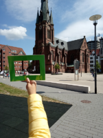 Then we gradually approached the surroundings that we had explored with the PhotoVoice Safari and searched for stores, places of residence and other so-called points of interest (POI) on the map table.
At Europaplatz in Herne-Mitte, for example, there is the Kreuzkirche (Church of the Holy Cross), which was rated as a “beautiful place” during the PhotoVoiceSafari and which could be located here on the map table. In addition to such points (geolocations) and paths from one point to the next, we also tested together different settings of the map: the map display from top view or also three-dimensional views, which perhaps one or the other knows from street map applications, as well as the change between these views for orientation in the city.
 We got to know many new aspects of the city and its places, exchanged ideas and used a lot of space and time for discussions, after all we want to develop a usable software!
The joint design of a digital planning software for cities and municipalities aims to give city planning and health departments the opportunity to better consider needs of people with disabilities and also to include them in planning by using the software.

OpenEdition schlägt Ihnen vor, diesen Beitrag wie folgt zu zitieren:
Myriam Vittinghoff (22. April 2023). Collaborative mapping. DiMDiCi. Abgerufen am 19. Juli 2026 von https://dimdici.hypotheses.org/866


